Showing posts with label Local History. Show all posts

Wednesday, June 7, 2017

Woodlawn Cemetery

     I recently had occasion to visit Woodlawn Cemetery in the Bronx, a place of great historic interest and the site of the graves of many noteworthy people.  Among others, I found:

General Sigel


Admiral Farragut, surrounded by members of his family.


     Remarkable also is that Mansfield Lovell, Confederate commander of New Orleans, is buried in the same cemetery as his victorious adversary Farragut.

Melville


     There are many other noteworthy burials here, including Albert Ellis, whose grave I searched for for quite some time before learning it is unmarked, and the extended Borden family, whose patriarch Gail invented powdered milk.


Tuesday, March 22, 2016

This Hand for My Country

Bit of an odd post today, and one I've been meaning to complete for some time.  In a way it's a lead-up to my next Federal regiment, the 80th (20th) NYSVI.  I will write more about them when the regiment is fully painted. 

At Second Bull Run the 80th was under Colonel George Pratt, who received mortal wounds while leading his men against Jackson's right flank on August 30th.  Pratt was born in what is now Prattsville in Greene County, NY, a town named for his father, Col. Zadock Pratt.  Col. Pratt was many things: tanner, businessman, militia officer, Congressman, reformer, banker, and developer.  One thing he was not, however, was modest.  Not only does Prattsville bear his name, but a large rockface outside of town, now known as Pratt's Rock, is covered with carvings he commissioned to commemorate himself and his family.  George Pratt, a state senator, businessman, militia officer, and amateur historian, moved to Kingston, NY, seat of Ulster County, and subsequently was involved with that county's militia.  After he was killed, he was of course added to Pratt's Rock.


Col. Zadock Pratt: "Tanner, Farmer, Builder, Banker, U.S. Congressman."  Pratt is also responsible for revolutionizing the postal system in the United States.  Previously, postage for letters and packages was paid by the addressee upon receipt of the item.  Transportation was costly, and therefore postage was high, so it was not uncommon for an addressee to refuse a letter upon its delivery, in which case the postal service would have to return it to the sender (and pay for the two-way trip, labor, etc.). Pratt, believing that the high cost discouraged people from corresponding, moved while in Congress for the system to be reformed.  The sender would pay postage prior to mailing, and postage would be kept low.  Since it would be simpler and cheaper to send letters, more people would send them, and a net increase in postage revenue would arise in time; at the same time, increased correspondence would stimulate intellectual and commercial development.  Pratt was so proud of this accomplishment that he ordered it engraved on his tombstone.


His son, Col. Pratt - one of many carvings on Pratt's Rock. 

G. Pratt from the front.


Also carved into the rock is an emblem the militia regiment, the Red Hand of Ulster, encircled by the words "This Hand for My Country," a phrase of Pratt's devising that would become a sort of motto for his regiment.


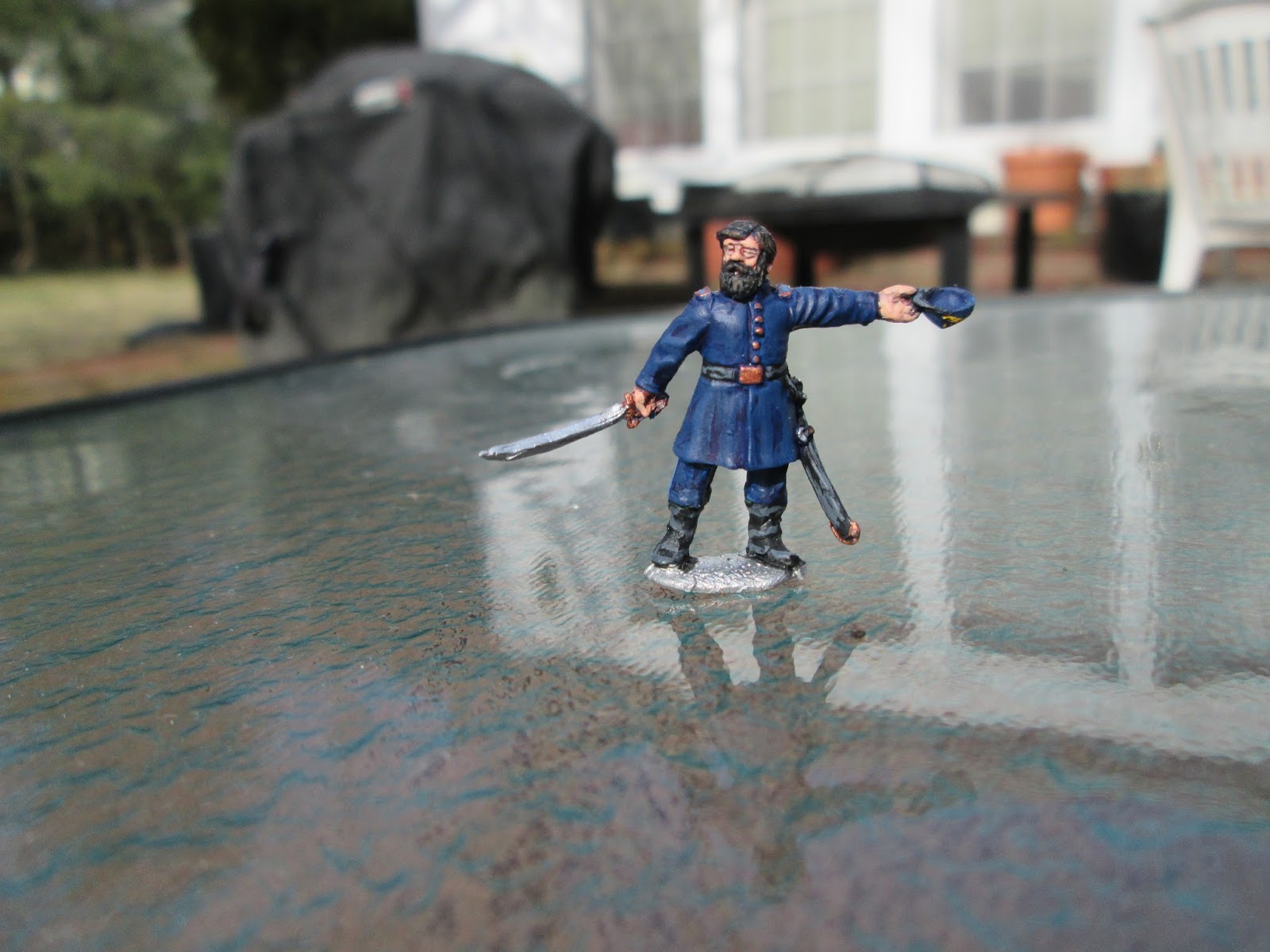
Here is Col. Pratt, urging his men toward the enemy.  The model is a fiddled-with Perry Union officer, who's been given boots, hair and beard, and a hat in his outstretched hand.

Monday, January 18, 2016

Young's Corners

     Every morning as I drive to work, I pass a little monument.  Recently, it occurred to me that I had never bothered to find out what it commemorates, so I pulled over to examine it and found that it marks the site of a common grave, discovered in 1922, of men killed at the Battle of Young's Corners (also known as Young's House or Four Corners), an engagement I'd never heard of.  

     There was, to my surprise, a quite detailed article on Wikipedia, which I encourage the reader to peruse.  I was interested in visiting the exact location of the battle and learning a bit more about it, however, and with the kind assistance of the librarian of the Westchester County Historical Society, I was able to pinpoint the location of the battle, aided in particular by an article written by a local historian, a Mr. William Abbatt, on the occasion of the discovery of the bones of the fallen in '22.

   Young's House was a tavern at the intersection of two local roads.  It served as a Patriot outpost during the rough years of the Revolution, when much of Westchester was a no-man's land ravaged by both sides.  In 1799, with the departure of a substantial part of the New York garrison for the Southern campaign,  the Continental army was at last able to establish its lines closer to the city.  General von Knyphausen, who now commanded the garrison, was an aggressive officer and planned a number of raids in strength on Continental strongpoints.  Young's House, held by five companies from Massachusetts regiments, was an obvious target, and on the evening of Feb. 2nd, 1780, an elite force of Guardsmen, Hessians, and the much-feared Westchester Refugees departed Kingsbridge in the Bronx and marched North.  The winter of 1779-80 was especially severe, and the deep snow delayed and disrupted the columns, so that they arrived piece-meal at the tavern the following morning.  Despite having been alerted to the presence of the British, Lt Col. Thompson, commanding the garrison, was totally unprepared for the attack, and in characteristically aggressive fashion the British and Hessians, though in some disorder from the march, fell on the defenders, flanked them on both sides, and, after a short but bloody encounter drove them off.  The Refugees rode down or captured many of the fleeing Continentals while the British fired the tavern, unfortunately burning to death several wounded men trapped in the building.  The operation was a total success, and the Tavern was not rebuilt, though Continental patrols frequently passed near it;  Major Andre, on his fateful voyage towards New York, deviated from his planned route to avoid men posted at "the burnt house."

     The only monument to the battle is this rather odd structure, which marks the common grave of both Continental and British soldiers who were killed.  It is in itself a somber and reverent memorial and stands in a grove of very stately Eastern red cedars.  What the photos don't show is that it is located on what is effectively a highway median (near the on-off ramps for the South-bound Sprain Brook Parkway).  It is a very noisy spot on account of the traffic, and it is also used as a staging/storage ground for road maintenance projects; the effect, needless to say, is less than peaceful.


     Looking east along Route 100C (Grasslands Road) towards the Sprain Brook Parkway.  On roughly this ground the British left column (Hessians and the light companies) engaged the Continentals: the company from the 15th under Roberts in what is now the road-bed of the Sprain Brook, and Stoddard's company from the 1st marching belatedly East along 100C and arriving just in time to participate in the general rout. Roberts' men put up stiff resistance for a few minutes, but while they were pinned the attackers slipped around Roberts' right flank and routed them.  Roberts was mortally wounded in the defense.  Incidentally, the grave marker is in the stand of conifers on the left.


     Using the map provided in Mr. Abbatt's article, I estimate Young's House to have stood more or less on the same spot as this building, near the main entrance of Blythedale Children's Hospital on Bradhurst Avenue.  There were also a number of outbuildings, as well as an orchard immediately to the tavern's North.  Lt. Col Thompson and Watson's company from the 9th Massachusetts were stationed here.  Apparently, the tavern's chimney survived the conflagration and was incorporated into a new house built after the war.


     Again looking East along Grasslands Road, this time toward Westchester Community College.  Farley's and Cooper's men (9th Massachusetts) were strung out in this direction, Farley's company driven off by the British right column and Cooper's arriving too late to do much of anything.


Thursday, December 17, 2015

Philipsburg Encampment, Part I


     Recently I went on a little expedition through what is often called the Philipsburg Encampment, the area in which the combined armies of General Washington and the Comte de Rochambeau passed much of the summer of 1781.  Rochambeau landed on the Rhode Island coast (the Royal Navy was interdicting the Long Island Sound) and marched westward across Connecticut to Westchester County, with the main body of his army arriving around July 4th.  For the next six weeks, the two armies staid put, the French doubtless suffering under the heat and humidity.
     During this period, Washington launched the "Grand Reconnaissance," a forceful probing of British strength in and around New York City, which Washington intended to seize.  Rochambeau, fearing that the city would prove too costly a prize, preferred to move southward, and when the Reconnaissance met stiff resistance, Washington began to come round to Rochambeau's line of thought.  Once word reached Washington of Admiral de Grasse's movement towards Virginia, the matter was settled, and the allied armies broke camp around 19th August, crossed the Hudson at Dobbs Ferry, and marched South to Yorktown and victory.
     What was then known as Philipsburg is now part of the town of Greenburgh.  The town, Westchester County and the Washington-Rochambeau Revolutionary Route have erected signs at various points on the site of the former encampment.


      Here is a map, posted at the Odell House, of the various points of interest in the Town of Greenburgh.  (Please note that the numbered dots indicate signs, not separate locations - this confused me at first).  

     The first stop on the route (signs 1 and 2) is the Odell House.  Built in the 1730s, it was in 1781 the headquarters of the Comte de Rochambeau, who also entertained the allied generals at dinner parties in a barn that stood nearby.  The Odell family, formerly an old and important family in Westchester County acquired the house shortly before 1800 (during the Revolution it belonged to a man called Bates) and kept it until the 1960's, at which point it was given to the County.  Like so many historic buildings, it is in rather poor repair thanks to our County Executive's decision that it is not the place of the government to look after such sites, which should be maintained by public donation only.


     The front elevation of the Odell House, taken from Ridge Road.
                        The rear of the house - here the poor state of the house is readily seen.

     One of the signs at the Odell House.

      The next stop was the site of the American Encampment, the bulk of which stretched on both sides of Heatherdell Road from approximately Sprain Brook to the Saw Mill River.  Outposts were also established in Ardsley and in Dobbs Ferry overlooking the Hudson, under the command of colonels Scammel and Sheldon respectively.  The encampment is commemorated in McDowell Park by a small sign (sign 3).


      Sign 4 is at the western end of the encampment, on Concord Road just north of the center of Ardsley.


      Signs 5 and 6 are in Ardsley proper and give a general picture of the campaign and a more detailed description of Washington's "grand reconnaissance" against the British in New York City and South Westchester.


     Curiously, the French encampment is not included in the Washington-Rochambeau Route's list of noteworthy places.  Its approximate location is marked by a sign on Underhill Road, and I presume it occupied what are now the grounds of the Sunningdale Country Club.


For Part II I hope to pin down the locations of the encampments East of the Bronx River.

Thursday, October 29, 2015

Battle of White Plains Anniversary

Yesterday, October 28th, was the anniversary of the Battle of White Plains, fought in 1776 near what is now the City of White Plains, NY.  For those of you not familiar with the engagement, suffice to say that it was an important battle in the British conquest of southern New York and precipitated Washington's retreat across the Hudson into New Jersey.  Once in New Jersey, the Continental Army won the battles of Trenton and Princeton, restoring the army's, and the nation's, morale after a long series of severe reverses.  Since it's only a short drive from my house to the battlefield, I decided to inspect the site more thoroughly than I had in the past to mark the anniversary.

Much of the battle was fought along Chatterto'sn Hill (now called Battle Hill), a long, steep-sided ridge that overlooks the Bronx River and guards the southern approach to the village of White Plains.  The village was sited on one of the very few flat pieces of ground in Westchester County, through which also ran most of the few roads that existed in the colonial period, most notably the Boston Post Road.  The Continental Army had retreated northward to White Plains after being driven from New York City and surrounds, and Lord Howe decided to force an engagement in the hope that Washington would finally capitulate.  In summary, Howe launched a fierce assault, throwing two columns across the Bronx River and up the sides of Chatterton's Hill.  The Continentals held their ground until the Hessian column under Rall, having seized another hill just South of Chatterton's, outflanked Washington's line and began to roll up his right flank.  As the Continental flank gave way, the British column carried the rest of the Hill, and Washington promptly withdrew to North Castle.

The battlefield today is largely a pleasant residential area, and the houses both obscure one's view of the field and preclude much tramping around in search of topographical features.  Washington's extreme left was situated where a memorial park now stands.


The park's flagstaff flies not only the Stars and Stripes but also the 1775 American flag and the flag of the City of White Plains, a sword and Phrygian cap with the motto "Liberty or Death."

It's a nice, quiet spot, and one can little imagine that it was the scene of a fairly ferocious fight. There are some signs that give a good impression of the course of the battle.


The "You are Here" marks the location of the park, on the Continental left.

Below the Hill is the memorial proper, which can also be glimpsed from one's car as one drives on the Bronx River Parkway.


While walking around, I tried to find the location of the Continental right flank, where the battle was decided by Rall's Hessians.  (Rall would himself be on the receiving end of a Continental assault only two months later at Trenton, where he was killed.)   It is of course difficult to use today's topography as a guide; the ground undulates considerably, and how much it has changed in the past 230 years I cannot say.  Nevertheless, by walking along the ridge-line I was able to come to the southern end of the hill, where the ground dipped down sharply to form a saddle between Chatterton's Hill and another hill immediately to the Southwest.  I presume this was the point where the Hessian battalions dislodged the defenders.  Those of you who might wish to visit the spot should look for the intersection of Lee and Chase streets.


The memorial park had been decorated with a few small American flags, but in general there seemed to be no sign that anyone had "observed" the anniversary.  Suddenly, however, I noticed a house flying the Pine Tree flag and a Liberty or Death flag - surely no coincidence.


Also, given the time of year, I was able to examine the many Halloween decorations that residents had put up.  This was my favorite: